![](/images/other/stat-length.png)
![Excursión Senderismo Bassillac et Auberoche - Blis-et-Born Fontbrejade 11km - Photo](https://media.geolcdn.com/t/1900/400/ext.pjpeg?maxdim=2&url=https%3A%2F%2Fstatic1.geolcdn.com%2Fsiteimages%2Fupload%2Ffiles%2F1553511878bg_sport_marche.png)
Blis-et-Born Fontbrejade 11km
YV24
Usuario
![Longitud](/images/other/stat-length.png)
Longitud
10,4 km
![Altitud máxima](https://static1.geolcdn.com/siteimages/upload/files/1508320355ic_sort_altitude_max_24dp.png)
Altitud máxima
227 m
![Desnivel positivo](https://static1.geolcdn.com/siteimages/upload/files/1508320355ic_sort_den_pos_24dp.png)
Desnivel positivo
228 m
![Km-Effort](/images/other/stat-length.png)
Km-Effort
13,5 km
![Altitud mínima](https://static1.geolcdn.com/siteimages/upload/files/1508320355ic_sort_altitude_min_24dp.png)
Altitud mínima
117 m
![Desnivel negativo](https://static1.geolcdn.com/siteimages/upload/files/1508320355ic_sort_den_neg_24dp.png)
Desnivel negativo
227 m
![Boucle](https://static1.geolcdn.com/siteimages/upload/files/16400158638029165_repeat_loop_refresh_sync_direction_icon.png)
Boucle
Sí
Fecha de creación :
2018-01-29 00:00:00.0
Última modificación :
2018-01-29 00:00:00.0
![Senderismo](https://static1.geolcdn.com/sitytour/trail-icons/101.png)
2h56
Dificultad : Fácil
![Escanee este código QR para abrir la excursión en la aplicación SityTrail](https://capi.geolives.com/qq0zvz2zws4bq2lad0pu/sitytour/trails/398352/qr.png?size=200)
Aplicación GPS de excursión GRATIS
A propósito
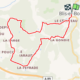
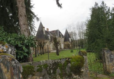
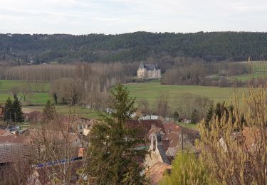
Ruta Senderismo de 10,4 km a descubrir en Nueva Aquitania, Dordogne, Bassillac et Auberoche. Esta ruta ha sido propuesta por YV24.
Descripción
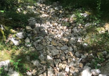
Fontbrejade selon PDIPR n°4 carte St Pierre de Chignac. Bien tracé, balisé, praticable en tout temps. Raidillon en fin de boucle.Le panneautage est optimiste avec ses 12,8km, c'est plutôt 10,6km.
Localización
País:
France
Región :
Nueva Aquitania
Departamento/provincia :
Dordogne
Municipio :
Bassillac et Auberoche
Localidad:
Unknown
Salida:(Dec)
Salida:(UTM)
335616 ; 5005289 (31T) N.
Comentarios
Excursiones cerca
![Excursión Senderismo Bassillac et Auberoche - Le Change Roc 9km - Photo](https://media.geolcdn.com/t/375/260/ext.jpg?maxdim=2&url=https%3A%2F%2Fstatic1.geolcdn.com%2Fsiteimages%2Fupload%2Ffiles%2F1553511878bg_sport_marche.png)
![Senderismo Senderismo](https://static1.geolcdn.com/sitytour/trail-icons/101.png)
Le Change Roc 9km
Senderismo
Muy fácil
(1)
Bassillac et Auberoche,
Nueva Aquitania,
Dordogne,
France
![](/images/other/stat-length.png)
9,3 km | 12,2 km-effort
2h 43min
![](https://static1.geolcdn.com/siteimages/upload/files/16400158638029165_repeat_loop_refresh_sync_direction_icon.png)
Sí
![Excursión Senderismo Bassillac et Auberoche - Le Change Pommiers 9km - Photo](https://media.geolcdn.com/t/375/260/ext.jpg?maxdim=2&url=https%3A%2F%2Fstatic1.geolcdn.com%2Fsiteimages%2Fupload%2Ffiles%2F1553511878bg_sport_marche.png)
![Senderismo Senderismo](https://static1.geolcdn.com/sitytour/trail-icons/101.png)
Le Change Pommiers 9km
Senderismo
Fácil
(1)
Bassillac et Auberoche,
Nueva Aquitania,
Dordogne,
France
![](/images/other/stat-length.png)
9 km | 11,3 km-effort
2h 32min
![](https://static1.geolcdn.com/siteimages/upload/files/16400158638029165_repeat_loop_refresh_sync_direction_icon.png)
Sí
![Excursión A pie Bassillac et Auberoche - Les chabannes - Photo](https://media.geolcdn.com/t/375/260/a8aade46-e147-4b35-b4a7-c1d555488ef4.jpg&format=jpg&maxdim=2)
![A pie A pie](https://static1.geolcdn.com/sitytour/trail-icons/100.png)
Les chabannes
A pie
Fácil
Bassillac et Auberoche,
Nueva Aquitania,
Dordogne,
France
![](/images/other/stat-length.png)
6,3 km | 8,2 km-effort
1h 52min
![](https://static1.geolcdn.com/siteimages/upload/files/16400158638029165_repeat_loop_refresh_sync_direction_icon.png)
Sí
![Excursión Senderismo Cubjac-Auvézère-Val d'Ans - Le chemin du Causse - Cubjac - Photo](https://media.geolcdn.com/t/375/260/ext.jpg?maxdim=2&url=https%3A%2F%2Fservices.sitytrail.com%2FGeolivesWS%2FDownloadMedia.ashx%3FTrailID%3D111446%26Media%3D7295_3.jpg)
![Senderismo Senderismo](https://static1.geolcdn.com/sitytour/trail-icons/101.png)
Le chemin du Causse - Cubjac
Senderismo
Medio
Cubjac-Auvézère-Val d'Ans,
Nueva Aquitania,
Dordogne,
France
![](/images/other/stat-length.png)
7,9 km | 10 km-effort
2h 0min
![](https://static1.geolcdn.com/siteimages/upload/files/16400158638029165_repeat_loop_refresh_sync_direction_icon.png)
Sí
![Excursión Senderismo Saint-Pierre-de-Chignac - boucle chai lamardie - Photo](https://media.geolcdn.com/t/375/260/21e6bc13-c5ca-4323-a746-a80ff6aa9b77.jpg&format=jpg&maxdim=2)
![Senderismo Senderismo](https://static1.geolcdn.com/sitytour/trail-icons/101.png)
boucle chai lamardie
Senderismo
Fácil
Saint-Pierre-de-Chignac,
Nueva Aquitania,
Dordogne,
France
![](/images/other/stat-length.png)
8,6 km | 11 km-effort
2h 45min
![](https://static1.geolcdn.com/siteimages/upload/files/16400158638029165_repeat_loop_refresh_sync_direction_icon.png)
Sí
![Senderismo Senderismo](https://static1.geolcdn.com/sitytour/trail-icons/101.png)
track
Senderismo
Muy difícil
Cubjac-Auvézère-Val d'Ans,
Nueva Aquitania,
Dordogne,
France
![](/images/other/stat-length.png)
15,4 km | 19,7 km-effort
4h 28min
![](https://static1.geolcdn.com/siteimages/upload/files/16400158638029165_repeat_loop_refresh_sync_direction_icon.png)
Sí
![Excursión Senderismo Montagnac-d'Auberoche - Boucle de la fontaine Marceau ( Montagnac d’ Auberoche) - Photo](https://media.geolcdn.com/t/375/260/dcf764e8-3947-4f29-9e0e-bbb82c8d0a4a.jpg&format=jpg&maxdim=2)
![Senderismo Senderismo](https://static1.geolcdn.com/sitytour/trail-icons/101.png)
Boucle de la fontaine Marceau ( Montagnac d’ Auberoche)
Senderismo
Fácil
Montagnac-d'Auberoche,
Nueva Aquitania,
Dordogne,
France
![](/images/other/stat-length.png)
6,9 km | 8,6 km-effort
2h 9min
![](https://static1.geolcdn.com/siteimages/upload/files/16400158638029165_repeat_loop_refresh_sync_direction_icon.png)
Sí
![Excursión Senderismo Cubjac-Auvézère-Val d'Ans - Boucle des Quatre Paroisses - Photo](https://media.geolcdn.com/t/375/260/760938ba-4fea-4056-a763-6c0429a09af1.jpg&format=jpg&maxdim=2)
![Senderismo Senderismo](https://static1.geolcdn.com/sitytour/trail-icons/101.png)
Boucle des Quatre Paroisses
Senderismo
Difícil
Cubjac-Auvézère-Val d'Ans,
Nueva Aquitania,
Dordogne,
France
![](/images/other/stat-length.png)
12,3 km | 15,9 km-effort
3h 36min
![](https://static1.geolcdn.com/siteimages/upload/files/16400158638029165_repeat_loop_refresh_sync_direction_icon.png)
Sí
![Excursión Senderismo Escoire - Boucle Escoire, départ de château. - Photo](https://media.geolcdn.com/t/375/260/3456106b-95e0-41d2-aaa1-fa25c824c727.jpg&format=jpg&maxdim=2)
![Senderismo Senderismo](https://static1.geolcdn.com/sitytour/trail-icons/101.png)
Boucle Escoire, départ de château.
Senderismo
Fácil
Escoire,
Nueva Aquitania,
Dordogne,
France
![](/images/other/stat-length.png)
12 km | 15,7 km-effort
3h 1min
![](https://static1.geolcdn.com/siteimages/upload/files/16400158638029165_repeat_loop_refresh_sync_direction_icon.png)
Sí